SUBJECT - EVS
TOPIC TAUGHT (TODAY)
CH -13 - MAPS AND GLOBES
Recapitulation (short questions-orally)
REVISED THE FOLLOWING TOPICS:-
SKETCH :- A sketch is a rough free hand drawing based on one's observation and memory.
PLAN :- Plan is a drawing of a small area which gives us details of a place when viewed from top.
MAP :- A flat drawing of the Earth, either whole or a part of it is called map. A map is a two- dimensional drawing of the earth.
WHOLE EARTH
There are three main types of maps
1. Physical map:- A physical map shows natural features of a place, such forests, mountains, rivers etc.
2. Political map:- A political map shows countries and their international and state borders. We can also locate the capital of each state on a political map.
For example , the political map of India given below shows the borders of various states in India along with the location of their capitals. It also shows India;s international border.
3. Thematic maps:- Thematic maps give specific information on a theme.
For example, types of soils in India, annual average rainfall, natural vegetation etc.
DIRECTIONS :- Directions help us locate unknown places on the map. We know the four main directions -- North, South, East and West. They are known as the cardinal directions or cardinal points.
FOUR MAIN DIRECTIONS
(NORTH, SOUTH, EAST , WEST)
INTERMEDIATE DIRECTIONS
The directions between the cardinal directions are known as intermediate directions. The intermediate directions are-NW (North-West), NE- (North-East), SW- (South- West), SE- (South-East).
HOW TO READ A MAP
A map has many essential features, which helps us to read and understand a map.
The essentials are as follows:-
1. Title :- The title tells us about the map and the type of information we will get from it.
2. Direction:- On the map, there is an arrow points towards the North and is represented by the letter N.
3. Scale:- A measurement of the map which represents the distance on the earth.
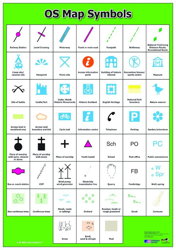
4. Colours and symbols:- Various features such as oceans, seas, mountains, plains, deserts, etc. are shown with the help of colours or symbols.
5. Key or legend:- A legend or key is a tool used ot understand symbols and colours used in a map.
PPT ON HOW TO READ MAPS SHOWN AND EXPLAINED.
Note - The practice of making maps is called cartography. The person who makes map is called a cartographer.
HOMEWORK
Draw the cardinal directions and label it . (Kindly complete it in your notebook).
Draw the intermediate directions and label it. (Kindly complete it in your notebook.)
Watch the videos on types of maps from your BetweenUs portal.
NOTE (1):-
COMPLETE THE NOTEBOOK WORK OF THE FOLLOWING CHAPTERS
- CH - 1 - FOOD AND HEALTH
- CH- 2 - SOIL
- CH- 5 - PLANT WORLD
- CH- 9 - CREEPY CRAWLIES
- CH- 3 - MATTERS : SOLIDS, LIQUIDS AND GASES
- CH- 4 - LIVING THINGS
- CH- 8 - BIRDS
- CH - 21- CARE AND COMPASSION
NOTE (2) :-
- KINDLY SEND THE NOTEBOOK WORK AT MY E-MAIL ID.
NOTE (3) :-
KINDLY COMPLETE THE WORKBOOK WORK AND UPLOAD ON YOUR BETWEENUS PORTAL (OF THE CHAPTERS TAUGHT)
NOTE (4) :- COMPLETE THE FOLLOWING ACTIVITY ON A HARD BOARD OR CHART PAPER
SCRAPBOOK ACTIVITY -1
1. PASTE OR DRAW PICTURES OF FOOD ITEMS RICH IN CARBOHYDRATES, PROTEIN, FATS AND VITAMINS AND MINERALS.
2. EXPLAIN EACH NUTRIENTS IN FEW LINES.
SCRAPBOOK ACTIVITY -2
PASTE DIFFERENT PARTS OF PLANTS THAT WE EAT
SCRAPBOOK ACTIVITY -3
DRAW, COLOUR AND LABEL THE LAYERS OF THE SOIL.
EXPLAIN EACH ON OF THEM.
SCRAPBOOK ACTIVITY -4
DRAW OR PASTE DIFFERENT TYPES OF SOIL
EXPLAIN ABOUT THEM.
COMPLETE THE ACTIVITES BY 22/08/2020 (SATURDAY)


